
Intense lake-effect snow shatters Thanksgiving record, as holiday travelers face dangerous roads home
MARQUETTE, Mich., – The biggest lake-effect snow event of the season is breaking records, delivering feet of snow to the Great Lakes Snowbelt and continuing to snarl holiday travelers driving and flying home from Thanksgiving on Friday, before the lake enhancement finally winds down.

Whiteout driving conditions near Grand Haven, Michigan on Wednesday. (Nate's Dronography via Storyful)

Winter storm causes crashes on Interstate 94 in Minnesota. (@MSPPIO_NW/X)

Winter storm causes crashes on Interstate 94 in Minnesota. (@MSPPIO_NW/X)

Winter storm causes crashes on Interstate 94 in Minnesota. (@MSPPIO_NW/X)

Winter storm causes crashes on Interstate 94 in Minnesota. (@MSPPIO_NW/X)

Whiteout conditions on Interstate 29 near Summit, South Dakota. (@SouthDakotaDOT/X)


On Friday, the wind will shift the heavier snow across the eastern portion of Michigan's Upper Peninsula, closer to Sault Ste. Marie, which had previously dodged the more intense snowbands.
THANKSGIVING WEEK STORM LIVE TRACKER: RADAR, FLIGHT DELAYS AND TRAVEL CANCELLATIONS AND FORECASTS
Friday's heaviest snow is expected to set up around Interstate 86 around Jamestown and Olean, New York.
Farther north, another potent snowband is expected across Interstate 90, reaching Rochester and Syracuse in central Upstate New York and potentially even Albany in New York's Capital Region.
The threat of rapidly changing, whiteout road conditions remains through Friday night.

(FOX Weather)
Parts of Interstate 90 just south of Erie, Pennsylvania were closed due to a disabled vehicle and speed restrictions were in place on Thanksgiving morning.
That comes after an initial winter storm system created treacherous travel conditions and caused hundreds of crashes and dozens of driving injuries across the Dakotas, Minnesota, Wisconsin and Michigan earlier this week.
THANKSGIVING WEEK STORM LIVE TRACKER: RADAR, FLIGHT DELAYS AND TRAVEL CANCELLATIONS AND FORECASTS

Snow plows clear lake-effect snow along Interstate 86 in Sherman, New York on Thanksgiving Day.
(Katie Byrne/ FOX Weather / FOX Weather)
Outside of Milwaukee, Ozaukee County officials said a semi tractor-trailer lost control and jackknifed across the median on Interstate 43 and hit two oncoming cars, leaving one person dead Wednesday afternoon.
More than 55,000 customers were without power early Thanksgiving morning across Wisconsin, Michigan and western New York.
Friday's strongest lake-effect impacts will be felt along the Great Lakes Snowbelt in Ohio, Pennsylvania, western New York and New York's Tug Hill Plateau, where Lake-effect Snow Warnings remain in effect.
According to the FOX Forecast Center, areas in western New York and northeastern Pennsylvania could still see close to a foot of snow from this event.
WINTER STORMS TO BRING DISASTROUS THANKSGIVING TRAVEL CONDITIONS FOR MILLIONS ACROSS 40+ STATES

(FOX Weather)
Snow totals topped 25 inches in Northern Wisconsin and Michigan's Upper Peninsula through Friday morning. Hurley, Michigan has tallied 31.3 inches of snow.
Gaylord, Michigan set a daily snowfall record on Thanksgiving with 13.1 inches, breaking the previous record of 10.1 inches set in 2023.

(FOX Weather)
National Weather Service offices are advising those who have to travel to prepare for rapidly deteriorating road conditions.
WHAT IS A WINTER STORM WARNING?
"When the snow bands come in, you literally can't see anything, so this is going to be a no travel zone," warned FOX Weather Meteorologist Britta Merwin.
Major highways that remain at greatest risk of blowing snow and life-threatening conditions include the Interstate 90 corridor across Ohio, Pennsylvania and New York, as well as Interstates 94, 75 and 69 in Michigan.
SAFETY TIPS FOR DRIVING THROUGH WINTER WEATHER

(FOX Weather)
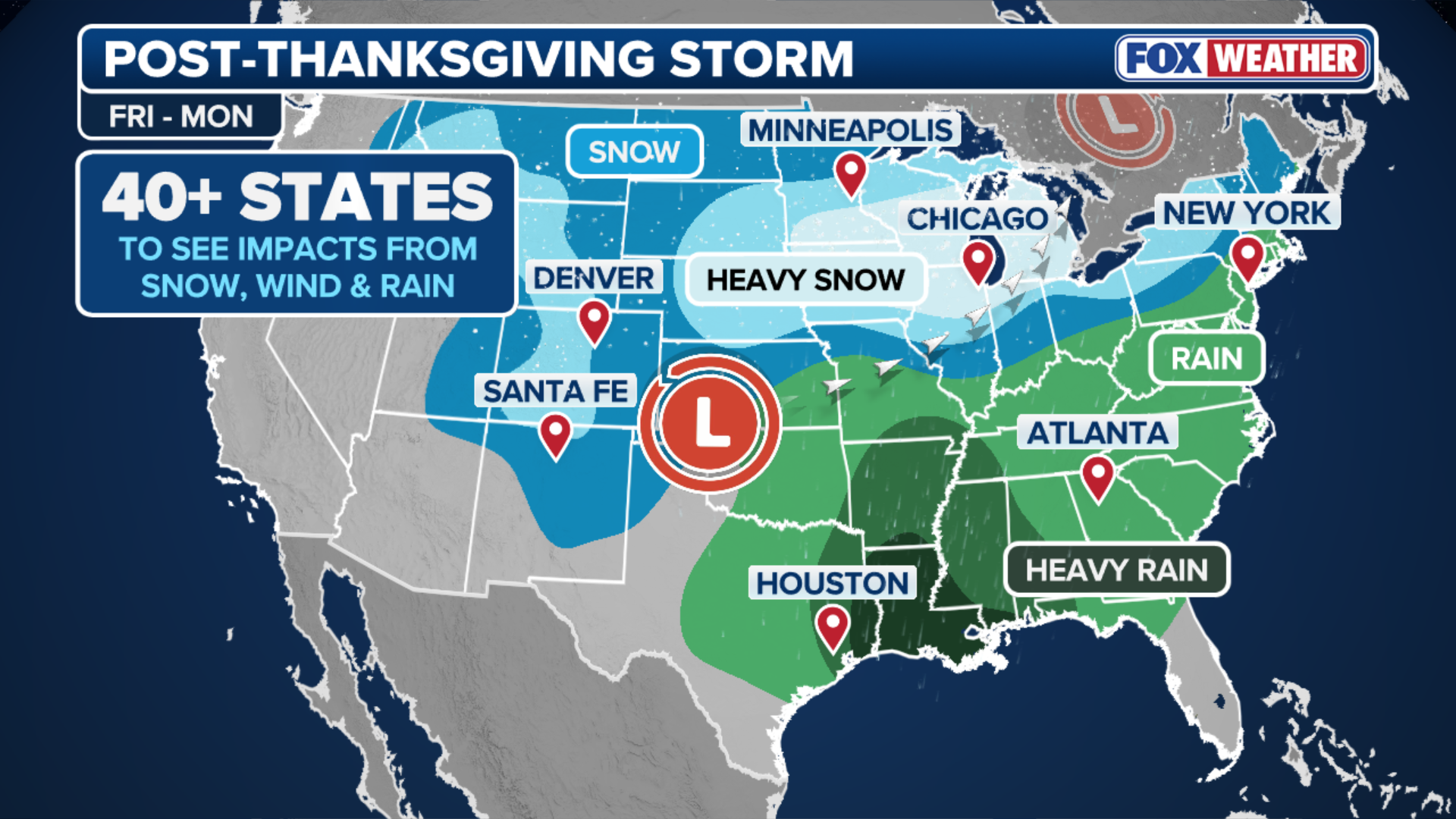
Second winter storm threatens millions across 40+ states
Meanwhile, the FOX Forecast Center is tracking a second winter storm that will impact millions across more than 40 states, just as many holiday travelers return home. Even more intense wind gusts and heavy snowfall are forecast for the central U.S. with the potential to cause significant delays at major airports across the Central U.S.
THESE ARE EXPECTED TO BE THE 10 BUSIEST US AIRPORTS THIS THANKSGIVING
(FOX Weather)
As millions begin to return home or head out for Black Friday shopping, an area of low pressure will develop in the Rockies, and is expected to bring Denver's first snow of the season.
The storm will move across the Central Plains Friday into Saturday, and is expected to bring 5–8 inches of snow across portions of Iowa, southern Wisconsin, and Illinois, according to the FOX Forecast Center.
HOW PILOTS NAVIGATE THROUGH DANGEROUS WEATHER CONDITIONS
Chicago is expected to see 8-12 inches of snow beginning Friday, which could rival its snowiest two-day total in November since records began in 1884, according to the Forecast Center.
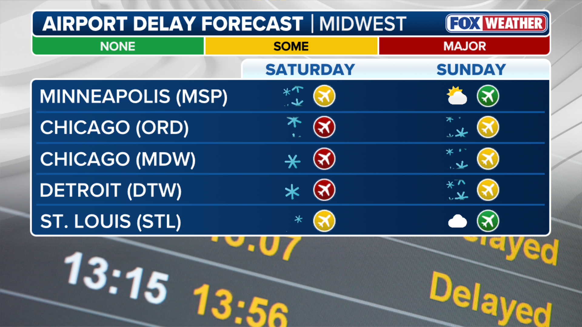
Chicago, Milwaukee and Detroit airports could all see significant delays due to wind and heavy snow.
(FOX Weather)
South of Interstate 70, the mid-Mississippi Valley and points south and east will see repeated rounds of heavy rain beginning Saturday, with rain reaching the East Coast by Sunday.
Travel impacts are expected to last into Monday.


0 Comments
Yorum ekle